
Ta'ãnga:Allemagne carte.png
No disponible a mayor resolución.
Allemagne_carte.png (328 × 352 píxeles; tamaño de archivo: 29 kB; tipo MIME: image/png)
Resumen
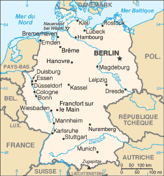
| Mombe'uanga | French map of Germany |
| Arange | of this version : February 2006 |
| Moõgui oguenohẽ |
CIA World Factbook / French Wikipedia |
| Apohára | of the translations : see history file |
| Permiso (Reutilización de este archivo) |
PD |
| Otras versiones | original English version : Image:Germany-CIA_WFB_Map.png |
Français : * Sujet : Carte en français de l'Allemagne ;
- Source : CIA World Factbook / Wikipédia francophone ;
- Autres versions disponibles :
- Fichier GIMP (francophone) disponible : http://fr.wikipedia.org/wiki/Image:De-map.xcf ;
- anglophone : Image:Germany-CIA_WFB_Map.png ;
- espagnol : Image:Gm-map-es.png ;
- finlandais : Image:Saksa-kartta.JPG ;
- japonais : Image:Gm-map-ja.png ;
- Auteurs des traductions : Voir l'historique ci-dessous ;
- Date : Février 2006.
File History of the French Wikipedia :
(suppr) (actu) 15 février 2006 à 21:02 . . Sting (Discuter) . . 328x352 (47 456 octets) ("Canal de Kiel" corrigé)
(suppr) (rétab) 3 février 2006 à 16:27 . . Sting (Discuter) . . 328x352 (47 058 octets) (Couleur Mer du Nord)
(suppr) (rétab) 10 janvier 2006 à 21:46 . . Truth (Discuter) . . 328x352 (45 224 octets) (carte de l'allemagne - origine https://www.cia.gov/library/publications/the-world-factbook/ archive copy at the Wayback Machine)
(suppr) (rétab) 10 janvier 2006 à 21:43 . . Truth (Discuter) . . 328x352 (45 224 octets) (carte de l'allemagne - origine https://www.cia.gov/library/publications/the-world-factbook/ archive copy at the Wayback Machine)
(suppr) (rétab) 18 septembre 2004 à 12:21 . . BernardM (Discuter) . . 328x352 (15 298 octets)
(suppr) (rétab) 18 septembre 2004 à 12:17 . . BernardM (Discuter) . . 328x352 (15 340 octets) (carte de l'Allemagne francisée)
(suppr) (rétab) 25 mai 2004 à 16:55 . . Luna04 (Discuter) . . 351x377 (25 226 octets) (carte de l'allemagne - origine https://www.cia.gov/library/publications/the-world-factbook/< {{msg:DomainePublic}})
Licencia
Esta imagen se encuentra en el dominio público ya que su contenido proviene de CIA World Factbook, un trabajo de la Agencia Central de Inteligencia de los Estados Unidos de América.
|
 |
Marandurenda rembiasakue
Ejopy peteĩ ára/aravo rehe rehecha hag̃ua pe marandurenda ojehechaukaháicha upe jave.
| Ára/Aravo | Michĩháicha | Tuichakue | Puruhára | Jehaimombyky | |
|---|---|---|---|---|---|
| ko’ag̃agua | 00:52 17 jasypoteĩ 2006 | | 328 × 352 (29 kB) | Sting | {{Information |Description=French map of Germany |Source=[http://www.cia.gov/cia/publications/factbook/ CIA World Factbook]<br/>/ French Wikipedia |Date=of this version : February 2006 |Author=of the translations : see history file |Permission=PD |other_v |
Marandurenda jeporu
No hay páginas que enlacen a este archivo.
Marandurenda jepuru opaite tembiapópe
Ko'ã ambue wiki oipuru ko marandurenda:
- Jeporu br.wikipedia.org rehe
- Jeporu fr.wikipedia.org rehe
- Jeporu ln.wikipedia.org rehe
- Jeporu nrm.wikipedia.org rehe