
Ta'ãnga:Map of USA with state names es.svg

Tamaño de esta previsualización PNG del archivo SVG: 800 × 495 píxeles. Otras resoluciones: 320 × 198 píxeles | 640 × 396 píxeles | 1024 × 633 píxeles | 1280 × 791 píxeles | 2560 × 1583 píxeles | 959 × 593 píxeles.
Marandurenda moambue'ỹre (archivo SVG, nominalmente 959 × 593 píxeles, tamaño de archivo: 407 kB)
Resumen
| Mombe'uanga |
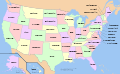
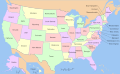
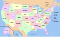
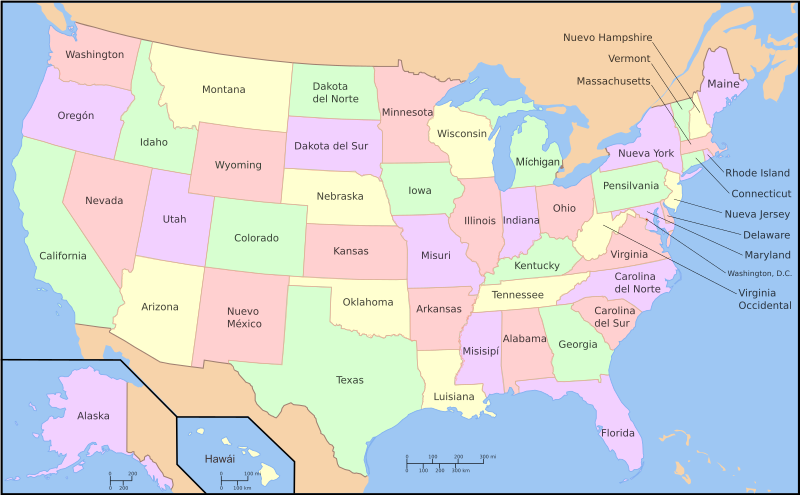
Español: Mapa de los es:Estados Unidos incluyendo los nombres de los estados en español. Esta imagen fue derivada y traducida por User:Szyslak de la imagen Image:Map of USA with state names.svg. La información en español fue del artículo es:Estado de los Estados Unidos.
English: This is a map of the w:United States with the w:U.S. state names in Spanish. This is a derivative work of Image:Map of USA with state names.svg, translated by User:Szyslak, based on es:Estado de los Estados Unidos. |
| Arange | 26 de jasyporundy de 2007 (fecha original de carga) |
| Moõgui oguenohẽ | No machine-readable source provided. Own work assumed (based on copyright claims). |
| Apohára | No machine-readable author provided. Szyslak assumed (based on copyright claims). |
| Otras versiones |
Este archivo deriva de: Map of USA with state names.svg |
- 20:57, 9 October 2005 . . Dbenbenn . . 959x593 (339217 bytes) (fix South Carolina label)
- 20:27, 9 October 2005 . . Dbenbenn . . 959x593 (339227 bytes) (typo, Massachussetts -> Massachusetts)
- 19:01, 9 October 2005 . . Dbenbenn . . 959x593 (371653 bytes) (crop, and remove some shapes (rivers, highways, capitals, lakes) that didn't display anyway)
- 13:18, 23 September 2005 . . Ed g2s . . 990x855 (978668 bytes) (fix (removed <image /> tag))
- 23:48, 23 September 2004 . . Wapcaplet . . 0x0 (978926 bytes) (SVG map of the United States. Created by Wapcaplet. {{GFDL}})
Licencia
Yo, titular de los derechos de autor de esta obra, la publico en los términos de las siguientes licencias:

|
Se autoriza la copia, distribución y modificación de este documento bajo los términos de la licencia de documentación libre GNU, versión 1.2 o cualquier otra que posteriormente publique la Fundación para el Software Libre; sin secciones invariables, textos de portada, ni textos de contraportada. Se incluye una copia de la dicha licencia en la sección titulada Licencia de Documentación Libre GNU. |
Este archivo se encuentra bajo la licencia Creative Commons Attribution-Share Alike 3.0 Unported, 2.5 Generic, 2.0 Generic and 1.0 Generic
- Nde reime sãsóme:
- de compartir – de copiar, distribuir y transmitir el trabajo
- de remezclar – de adaptar el trabajo
- Bajo las siguientes condiciones:
- atribución – Debes otorgar el crédito correspondiente, proporcionar un enlace a la licencia e indicar si realizaste algún cambio. Puedes hacerlo de cualquier manera razonable pero no de manera que sugiera que el licenciante te respalda a ti o al uso que hagas del trabajo.
- compartir igual – En caso de mezclar, transformar o modificar este trabajo, deberás distribuir el trabajo resultante bajo la misma licencia o una compatible como el original.
Puedes usar la licencia que prefieras.
[]
- Multilingual
 |
 |
 |
 |
 |
 |
 |
 |
 |
 |
 |
 |
 |
 |
 |
 |
 |
 |
 |
 |
 |
 |
 |
 |
 |
 |
 |
 |
 |
 |
 |
 |
 |
 |
 |
 |
 |
 |
 |
 |
 |
 |
 |
 |
 |
 |
 |
 |
 |
 |
 |
 |
 |
 |
 |
 |
 |
 |
 |
 |
 |
 |
 |
 |
 |
 |
 |
 |
 |
 |
 |
 |
 |
 |
 |
 |
 |
 |
 |
 |
 |
 |
 |
 |
 |
 |
 |
 |
 |
 |
 |
 |
 |
 |
 |
 |
 |
 |
 |
 |
 |
 |
 |
 |
 |
 |
 |
 |
 |
 |
 |
 |
 |
 |
 |
 |
 |
 |
 |
 |
 |
 |
 |
 |
 |
 |
 |
 |
 |
 |
 |
 |
 |
 |
 |
 |
 |
 |
 |
 |
 |
 |
 |
 |
 |
 |
 |
 |
 |
 |
-
 anarâškielâ
 -
 bosanski
 -
 Diné bizaad
 -
 eesti
eesti -
 English and all languages
 -
 English
 -
 español
 -
 Esperanto
 -
 euskara
 -
 français
 -
 galego
 -
 Hawaiʻi
 -
 hrvatski
 -
 italiano
 -
 magyar
 -
 occitan PNG
 -
 polski
 -
 português
 -
 română
 -
 Scots
Scots -
 slovenčina
 -
 suomi
suomi -
 svenska
 -
 ślůnski
 -
 Ἀρχαία ἑλληνικὴ
 -
 Ελληνικά
 -
 български
 -
 македонски
 -
 нохчийн
 -
 русский
 -
 русский 2
 -
 српски (ћирилица)
 -
 українська
 -
 ქართული PNG
 -
 қазақша
 -
 मराठी
मराठी -
 हिन्दी
 -
 অসমীয়া
 -
 বাংলা
বাংলা -
 বিষ্ণুপ্রিয়া মণিপুরী
 -
 ਪੰਜਾਬੀ
 -
 മലയാളം
 -
 ไทย
ไทย -
 ᏣᎳᎩ
ᏣᎳᎩ -
 中文(简体)
 -
 中文(繁體)
 -
 עברית
עברית -
 اردو
اردو -
 العربية
 -
 فارسی
فارسی -
 فارسی JPG


.svg)


Marandurenda rembiasakue
Ejopy peteĩ ára/aravo rehe rehecha hag̃ua pe marandurenda ojehechaukaháicha upe jave.
| Ára/Aravo | Michĩháicha | Tuichakue | Puruhára | Jehaimombyky | |
|---|---|---|---|---|---|
| ko’ag̃agua | 08:45 30 jasyteĩ 2013 | | 959 × 593 (407 kB) | Furado | Arreglando un problema con las fuentes en los nombres de dos estados. |
| 08:03 28 jasyteĩ 2013 |  | 959 × 593 (714 kB) | Furado | Añadidos dos acentos (Hawái y Míchigan) de acuerdo con la ortografía de la Real Academia Española. | |
| 23:00 26 jasyporundy 2007 |  | 959 × 593 (721 kB) | Szyslak | trying again, this time with consistent fonts - aside from working around my computer not having the document's original font, converting text to paths accounts for any (rare) case where a computer doesn't support Spanish accents | |
| 11:29 26 jasyporundy 2007 |  | 959 × 593 (383 kB) | Szyslak | converted all text objects into paths for consistent appearance, fixed accent error on Hawaii (Hawaí) | |
| 10:56 26 jasyporundy 2007 |  | 959 × 593 (383 kB) | Szyslak | converted double-line text objects to paths - hopefully this will preserve the original typeface, which my computer apparently doesn't have | |
| 10:27 26 jasyporundy 2007 |  | 959 × 593 (330 kB) | Szyslak | changed flow text to plain text | |
| 09:56 26 jasyporundy 2007 |  | 959 × 593 (330 kB) | Szyslak | ===Español=== Un mapa de los eswiki:Estados Unidos incluyendo los nombres de los estados en español. Este imagen fue derivado y traducido por User:Szyslak del imagen Image:Map of USA with state names.svg. La información en español fue del |
Marandurenda jeporu
Las siguientes páginas usan este archivo:
Marandurenda jepuru opaite tembiapópe
Ko'ã ambue wiki oipuru ko marandurenda:
- Jeporu ast.wikipedia.org rehe
- Jeporu ca.wikipedia.org rehe
- Jeporu es.wikipedia.org rehe
- Jeporu es.wiktionary.org rehe
- Jeporu lfn.wikipedia.org rehe