
Ta'ãnga:Nukuoro ISS013-E-28610.jpg
Tamaño de esta previsualización: 800 × 519 píxeles. Otras resoluciones: 320 × 208 píxeles | 640 × 415 píxeles | 1024 × 665 píxeles | 1280 × 831 píxeles | 3008 × 1952 píxeles.
Marandurenda moambue'ỹre (3008 × 1952 píxeles; tamaño de archivo: 612 kB; tipo MIME: image/jpeg)
Resumen
| Mombe'uanga |
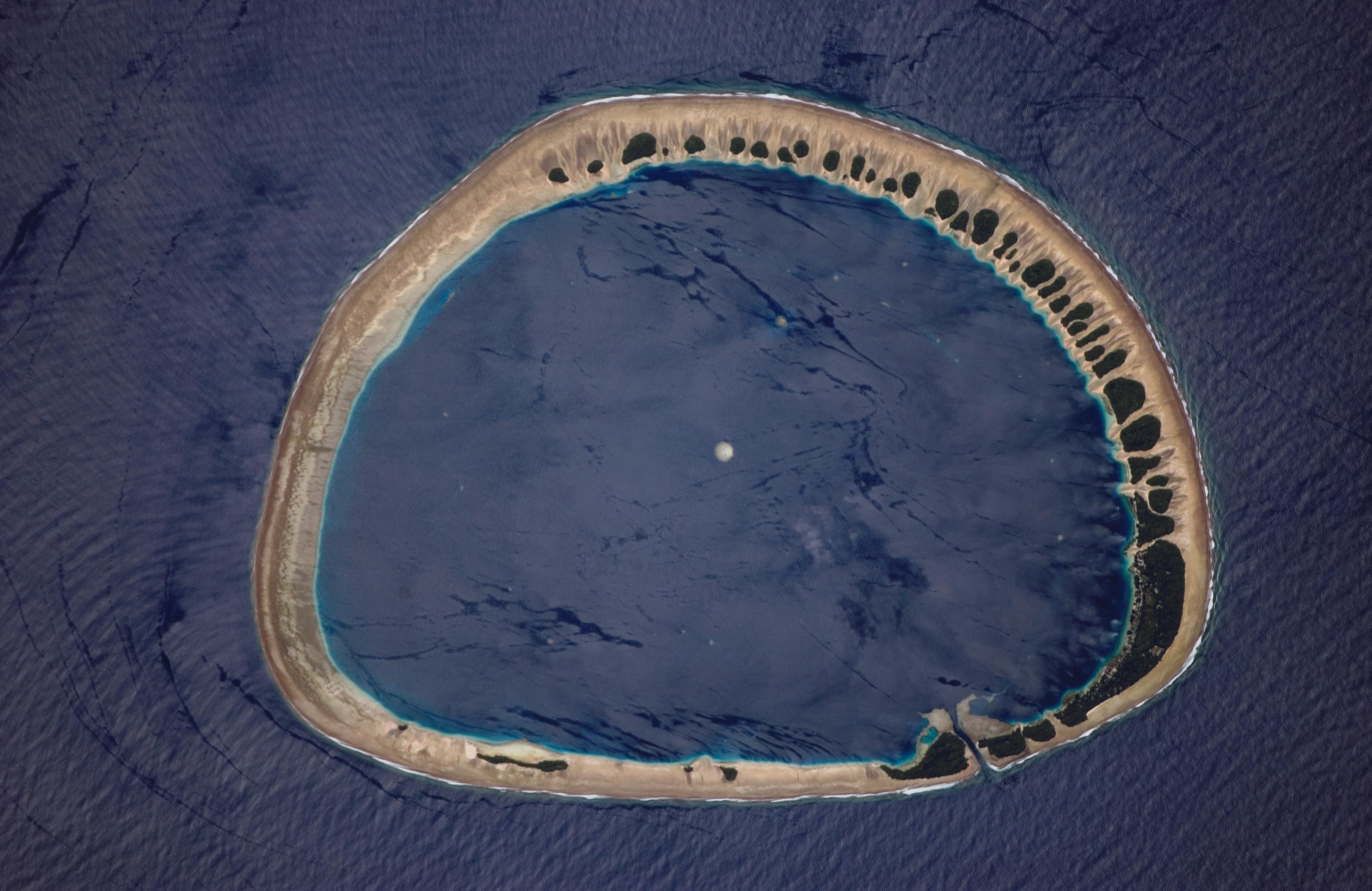
English: The atoll of Nukuoro, a polynesian exclave in the Federated States of Micronesia. The image shows the sandy atoll with 42 distinct patches of vegetation. These patches are located on the northeast and east portions of the atoll that face the dominant easterly winds. The detailed image (white box indicates area shown) shows the larger fields and settlements, which are on the inland side of the largest forest patch, protected from the wind. The land surface is probably slightly higher above sea level here because dunes build up preferentially on wind-facing slopes where beach sand is mobilized by wind. Swells driven by these winds approach from the east-southeast (right) and wrap around the atoll to produce an interference pattern on the downwind side. Water in the lagoon is notably calm in comparison. Coral heads appear in the lagoon, including one in the center of the image. |
| Arange | |
| Moõgui oguenohẽ | http://earthobservatory.nasa.gov/Newsroom/NewImages/images.php3?img_id=17331 (direct link, Unprocessed image) |
| Apohára | NASA/Johnson Space Center, Image Science & Analysis Laboratory |
| Permiso (Reutilización de este archivo) |
Public domain |
Este archivo fue catalogado por Johnson Space Center de la Administración Nacional de Aeronáutica y del Espacio (NASA) de los Estados Unidos de Américabajo el identificador de foto: ISS013-E-28610.Esta etiqueta no indica el estado de los derechos de autor del trabajo adjunto. Se requiere una etiqueta de derechos de autor normal. Para más información vea Commons:Sobre las licencias. Otros idiomas:
|
Licencia
"The Gateway to Astronaut Photography of Earth". Imagen cortesía de Image Science & Analysis Laboratory, NASA Johnson Space Center.
Fuente de la foto: ISS013-E-28610.
|
Marandurenda rembiasakue
Ejopy peteĩ ára/aravo rehe rehecha hag̃ua pe marandurenda ojehechaukaháicha upe jave.
| Ára/Aravo | Michĩháicha | Tuichakue | Puruhára | Jehaimombyky | |
|---|---|---|---|---|---|
| ko’ag̃agua | 05:56 13 jasykõi 2010 | | 3008 × 1952 (612 kB) | Telim tor | high-res AND correctly oriented |
| 23:20 6 jasyporundy 2007 |  | 1000 × 652 (394 kB) | Pmsyyz | reverted to version that may be smaller, but correctly oriented and matches description | |
| 03:23 5 jasypoapy 2006 |  | 3008 × 1952 (1,16 MB) | Bricktop | larger | |
| 01:28 15 jasypokõi 2006 |  | 1000 × 652 (394 kB) | Pmsyyz | {{Information |Description=The atoll of w:Nukuoro. |Source=http://earthobservatory.nasa.gov/Newsroom/NewImages/Images/ISS013-E-28610_lrg.jpg [http://earthobservatory.nasa.gov/Newsroom/NewImages/images.php3?img_id=17331] |Date=2006-05-31 |Author= |Per |
Marandurenda jeporu
La siguiente página usa este archivo:
Marandurenda jepuru opaite tembiapópe
Ko'ã ambue wiki oipuru ko marandurenda:
- Jeporu ace.wikipedia.org rehe
- Jeporu ar.wikipedia.org rehe
- Jeporu ast.wikipedia.org rehe
- Jeporu azb.wikipedia.org rehe
- Jeporu az.wikipedia.org rehe
- Jeporu be-tarask.wikipedia.org rehe
- Jeporu be.wikipedia.org rehe
- Jeporu br.wikipedia.org rehe
- Jeporu ca.wikipedia.org rehe
- Jeporu ceb.wikipedia.org rehe
- Jeporu de.wikipedia.org rehe
- Jeporu en.wikipedia.org rehe
- Jeporu en.wiktionary.org rehe
- Jeporu eo.wikipedia.org rehe
- Jeporu es.wikipedia.org rehe
- Jeporu es.wikibooks.org rehe
- Jeporu eu.wikipedia.org rehe
- Jeporu fa.wikipedia.org rehe
- Jeporu fi.wikipedia.org rehe
- Jeporu fr.wikipedia.org rehe
- Jeporu gl.wikipedia.org rehe
- Jeporu ha.wikipedia.org rehe
- Jeporu he.wikipedia.org rehe
- Jeporu it.wikipedia.org rehe
- Jeporu ja.wikipedia.org rehe
- Jeporu kaa.wikipedia.org rehe
- Jeporu ka.wikipedia.org rehe
- Jeporu ka.wiktionary.org rehe
- Jeporu kbd.wikipedia.org rehe
- Jeporu la.wikipedia.org rehe
- Jeporu lt.wikipedia.org rehe
- Jeporu lv.wikipedia.org rehe
- Jeporu mk.wikipedia.org rehe
- Jeporu ml.wikipedia.org rehe
Ver más uso global de este archivo.