
Ta'ãnga:Regions of bhutan labeled-roman script.svg

Tamaño de esta previsualización PNG del archivo SVG: 800 × 435 píxeles. Otras resoluciones: 320 × 174 píxeles | 640 × 348 píxeles | 1024 × 557 píxeles | 1280 × 696 píxeles | 2560 × 1393 píxeles | 875 × 476 píxeles.
Marandurenda moambue'ỹre (archivo SVG, nominalmente 875 × 476 píxeles, tamaño de archivo: 244 kB)
| Mombe'uanga |
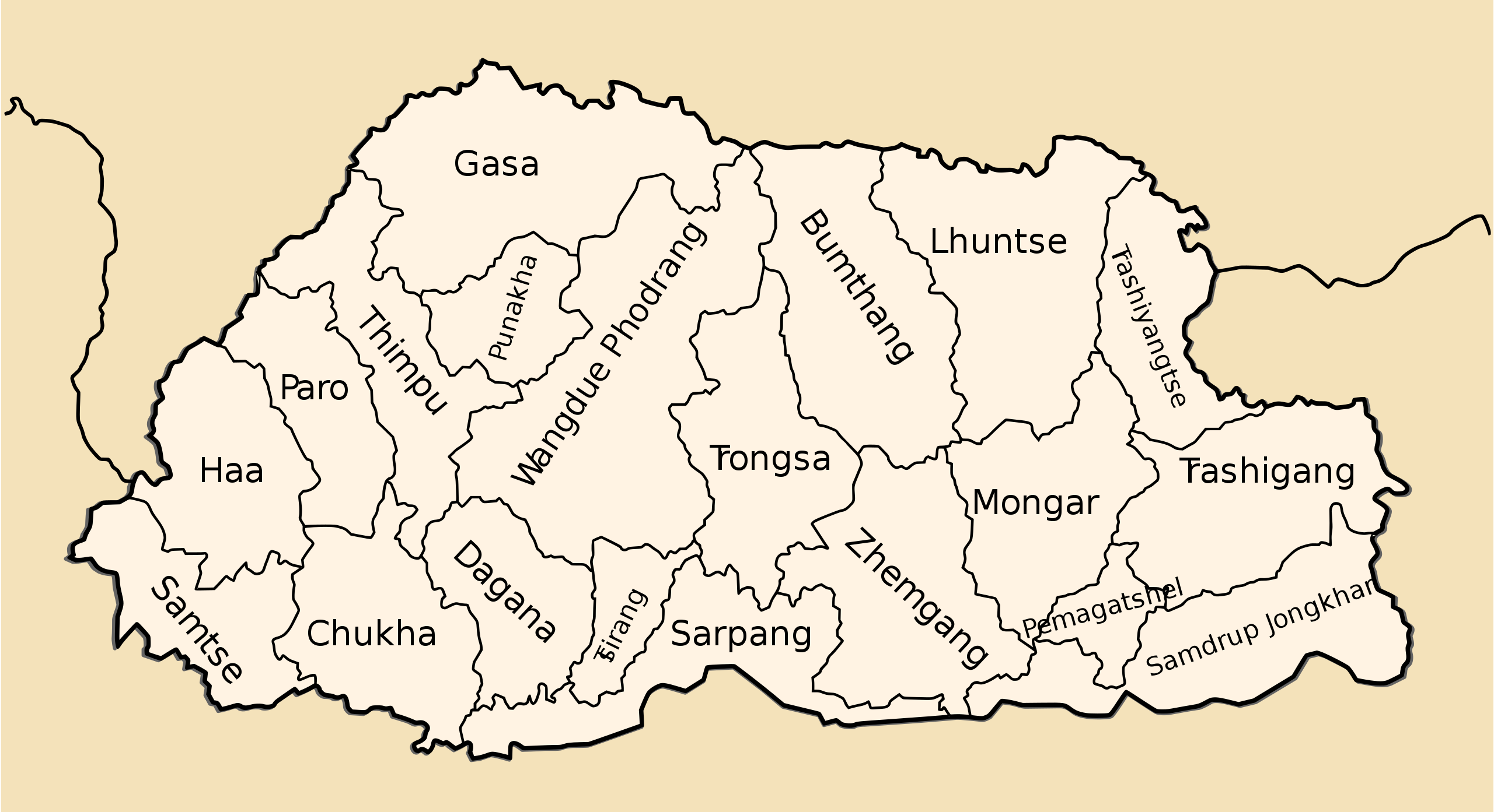
An SVG version of Nichalp map of the regions of Bhutan Bhutan subdivisions numbered Drawn by me, Nichalp |
| Arange | (UTC) |
| Moõgui oguenohẽ | |
| Apohára |
|
| Otras versiones |
Derivative works of this file: |
| Esta es una imagen retocada, lo que significa que ha sido alterada digitalmente de su versión original. Modificaciones: Added in-place labels based on Nichalp's original. La original se puede ver aquí: Bhutan-divisions-numbered.png. Las modificaciones las hizo Babbage.
|
Este archivo se encuentra bajo la licencia Creative Commons Genérica de Atribución/Compartir-Igual 3.0.
- Nde reime sãsóme:
- de compartir – de copiar, distribuir y transmitir el trabajo
- de remezclar – de adaptar el trabajo
- Bajo las siguientes condiciones:
- atribución – Debes otorgar el crédito correspondiente, proporcionar un enlace a la licencia e indicar si realizaste algún cambio. Puedes hacerlo de cualquier manera razonable pero no de manera que sugiera que el licenciante te respalda a ti o al uso que hagas del trabajo.
- compartir igual – En caso de mezclar, transformar o modificar este trabajo, deberás distribuir el trabajo resultante bajo la misma licencia o una compatible como el original.
Registro original de carga
This image is a derivative work of the following images:
- File:Bhutan-divisions.svg licensed with Cc-by-3.0
- 2010-10-17T06:25:26Z Babbage 744x405 (53590 Bytes) {{Information |Description=An SVG version of [[User:Nichalp|Nichalp]] map of the regions of Bhutan |Source=*[[:File:Bhutan-divisions-numbered.png|]] |Date=2010-10-17 06:20 (UTC) |Author=*[[:File:Bhutan-divisions.svg|]]: [[Use
- File:Bhutan-divisions-numbered.png licensed with PD-self
Uploaded with derivativeFX
Marandurenda rembiasakue
Ejopy peteĩ ára/aravo rehe rehecha hag̃ua pe marandurenda ojehechaukaháicha upe jave.
| Ára/Aravo | Michĩháicha | Tuichakue | Puruhára | Jehaimombyky | |
|---|---|---|---|---|---|
| ko’ag̃agua | 20:35 26 jasypa 2010 | | 875 × 476 (244 kB) | Babbage | Added layers to svg |
| 20:09 26 jasypa 2010 |  | 875 × 476 (254 kB) | Babbage | More legible color scheme. | |
| 07:36 18 jasypa 2010 |  | 875 × 476 (254 kB) | Babbage | == {{int:filedesc}} == == {{int:filedesc}} == Districts of Bhutan | |
| 07:21 17 jasypa 2010 |  | 900 × 700 (71 kB) | Babbage | {{Information |Description=An SVG version of Nichalp map of the regions of Bhutan Bhutan subdivisions numbered Drawn by me, Nichalp |Source=*File:Bhutan-divisions.svg *File:Bhutan-divisions-numbered.png |Date |
Marandurenda jeporu
No hay páginas que enlacen a este archivo.
Marandurenda jepuru opaite tembiapópe
Ko'ã ambue wiki oipuru ko marandurenda:
- Jeporu en.wikipedia.org rehe
- Jeporu ja.wikipedia.org rehe
- Jeporu sco.wikipedia.org rehe