
Ta'ãnga:COVID-19 Outbreak World Map.svg

Marandurenda moambue'ỹre (archivo SVG, nominalmente 2921 × 1500 píxeles, tamaño de archivo: 1,72 MB)

|
Este archivo podría ser actualizado para indicar nueva información. Si desea utilizar una versión específica del archivo sin reflejar actualizaciones posteriores, suba la versión deseada como un archivo separado. |
Resumen
| Mombe'uanga |
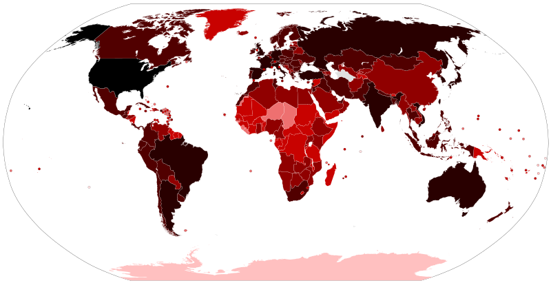
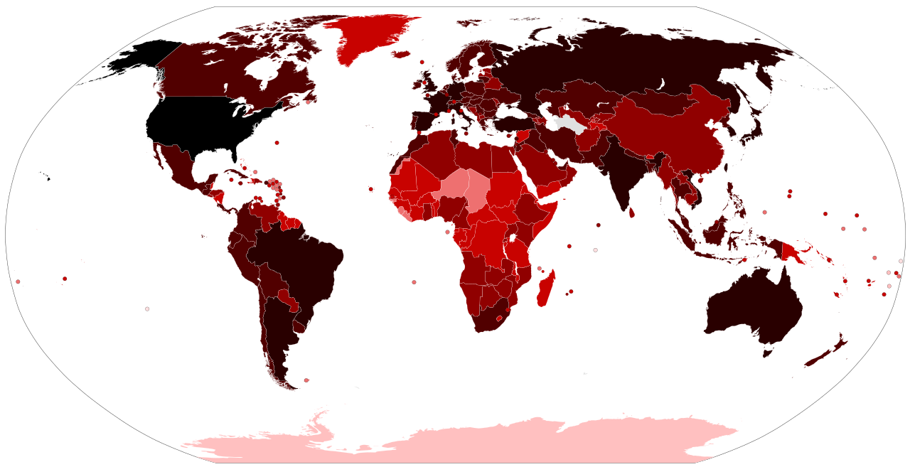
Map of the COVID-19 outbreak. Total cumulative confirmed COVID-19 cases by country. See the file history farther down for the latest upload date. Be aware that since this is a rapidly evolving situation, new cases may not be immediately represented visually. Refer to the primary article COVID-19 pandemic or the World Health Organization's situation reports for most recent reported case information. Legend information: 100,000,000+ Confirmed cases 10,000,000–99,999,999 Confirmed cases 1,000,000–9,999,999 Confirmed cases 100,000–999,999 Confirmed cases 10,000–99,999 Confirmed cases 1,000–9,999 Confirmed cases 100–999 Confirmed cases 1–99 Confirmed cases No confirmed cases, no population, or no data available |
| Arange |
– Date of first upload to the Wikimedia Commons. See the file history farther down for the latest upload date. Update the "point in time" date in the Wikidata entry linked below. {{wikidata|property|Q101240885|P585}} is used in map captions on Wikipedia. It provides the map date. To enable the date change click the purge link after updating the Wikidata entry. |
| Moõgui oguenohẽ |
Latest versions: https://ourworldindata.org/explorers/coronavirus-data-explorer?tab=map&Metric=Confirmed+cases&Interval=Cumulative&Relative+to+Population=false&Align+outbreaks=false&country=~OWID_WRL - Our World in Data. Click on the download tab to download map. The table tab has a table of the exact data by country. Source tab says data is from the COVID-19 Data Repository by the Center for Systems Science and Engineering (CSSE) at Johns Hopkins University. The map at the source is interactive and provides much more detail. For example, run your cursor over the color bar legend to see the countries that apply to that point in the legend. |
| Apohára |
Various Commons editors. See file history for latest ones. Older versions: Svenskbygderna (original author); Ratherous, AKS471883 (contributors); authors of File:BlankMap-World.svg (source file) |
| Otras versiones |
|
| SVG desarrollo | El código fuente de esta imagen SVG es inválido por un error. |


Licencia
- Nde reime sãsóme:
- de compartir – de copiar, distribuir y transmitir el trabajo
- de remezclar – de adaptar el trabajo
- Bajo las siguientes condiciones:
- atribución – Debes otorgar el crédito correspondiente, proporcionar un enlace a la licencia e indicar si realizaste algún cambio. Puedes hacerlo de cualquier manera razonable pero no de manera que sugiera que el licenciante te respalda a ti o al uso que hagas del trabajo.
Marandurenda rembiasakue
Ejopy peteĩ ára/aravo rehe rehecha hag̃ua pe marandurenda ojehechaukaháicha upe jave.
| Ára/Aravo | Michĩháicha | Tuichakue | Puruhára | Jehaimombyky | |
|---|---|---|---|---|---|
| ko’ag̃agua | 14:21 14 jasypoteĩ 2023 | | 2921 × 1500 (1,72 MB) | AKS471883 | Macao 10000 |
| 16:55 25 jasykõi 2023 |  | 2921 × 1500 (1,72 MB) | AKS471883 | Taiwan 10000000 | |
| 02:10 17 jasyteĩ 2023 |  | 2921 × 1500 (1,72 MB) | AKS471883 | Argentina 10000000 Channel Islands 100000 | |
| 05:56 24 jasypakõi 2022 |  | 2921 × 1500 (1,72 MB) | AKS471883 | Tokelau 5 | |
| 03:26 20 jasypakõi 2022 |  | 2921 × 1500 (1,72 MB) | AKS471883 | Uruguay 1000000 | |
| 03:02 16 jasypakõi 2022 |  | 2921 × 1500 (1,72 MB) | AKS471883 | Mongolia 1000000 | |
| 11:07 14 jasypakõi 2022 |  | 2921 × 1500 (1,72 MB) | AKS471883 | Macao 1000 | |
| 05:50 4 jasypakõi 2022 |  | 2921 × 1500 (1,72 MB) | AKS471883 | Panama 1000000 | |
| 03:09 24 jasypateĩ 2022 |  | 2921 × 1500 (1,72 MB) | AKS471883 | GUAM | |
| 16:47 22 jasypateĩ 2022 |  | 2921 × 1500 (1,72 MB) | S17003 | USA 100000000 |
Marandurenda jeporu
Las siguientes páginas usan este archivo:
Marandurenda jepuru opaite tembiapópe
Ko'ã ambue wiki oipuru ko marandurenda:
- Jeporu af.wikipedia.org rehe
- Jeporu als.wikipedia.org rehe
- Jeporu ar.wikipedia.org rehe
- Jeporu ar.wikinews.org rehe
- Jeporu ast.wikipedia.org rehe
- Jeporu az.wikipedia.org rehe
- Jeporu be.wikipedia.org rehe
- Jeporu bh.wikipedia.org rehe
- Jeporu bn.wikipedia.org rehe
- Jeporu bs.wikipedia.org rehe
- Jeporu ca.wikipedia.org rehe
- Jeporu cs.wikipedia.org rehe
- Jeporu da.wikipedia.org rehe
- Jeporu de.wikipedia.org rehe
- Jeporu de.wikinews.org rehe
- Jeporu el.wikipedia.org rehe
- Jeporu en.wikipedia.org rehe
- User:LightandDark2000
- User:JeremyNguyenGCI/sandbox
- Wikipedia:Top 25 Report/January 19 to 25, 2020
- COVID-19 pandemic by country and territory
- Talk:COVID-19 pandemic by country and territory/Archive 1
- Wikipedia:Top 25 Report/January 26 to February 1, 2020
- Wikipedia talk:WikiProject Medicine/Archive 132
- Wikipedia:Top 25 Report/February 2 to 8, 2020
- Wikipedia:Top 25 Report/February 9 to 15, 2020
- Wikipedia:Top 25 Report/February 16 to 22, 2020
- Wikipedia:Wikipedia Signpost/2020-03-01/Traffic report
- Wikipedia:Top 25 Report/February 23 to 29, 2020
- Wikipedia:Wikipedia Signpost/Single/2020-03-01
- Wikipedia:Top 25 Report/March 1 to 7, 2020
- Wikipedia:Top 25 Report/March 8 to 14, 2020
- Wikipedia talk:In the news/Archive 74
- Template talk:COVID-19 pandemic/Archive 1
Ver más uso global de este archivo.