
Ta'ãnga:Latin America (orthographic projection).svg

Tamaño de esta previsualización PNG del archivo SVG: 550 × 550 píxeles. Otras resoluciones: 240 × 240 píxeles | 480 × 480 píxeles | 768 × 768 píxeles | 1024 × 1024 píxeles | 2048 × 2048 píxeles.
Marandurenda moambue'ỹre (archivo SVG, nominalmente 550 × 550 píxeles, tamaño de archivo: 510 kB)
Resumen
| Mombe'uanga |
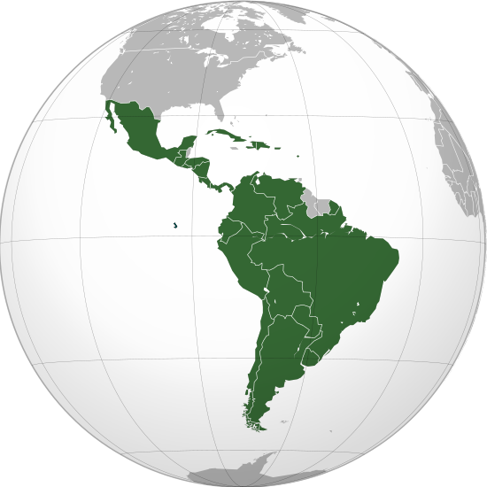
English: Latin America (orthographic projection). In grey Canada, USA, Belize, Guyana, Suriname, Trinidad and Tobago, Jamaica, the Bahamas, the Falklands. |
||
| Arange | |||
| Moõgui oguenohẽ | Apohára rembiapo tee | ||
| Apohára | Heraldry | ||
| Permiso (Reutilización de este archivo) |
|
||
| Otras versiones |
Obras derivadas de ésta: French America (orthographic projection).svg .svg) |
||
| SVG desarrollo | El código fuente de esta imagen SVG es inválido por un error. SVG watermarked with invisible embedded text. |

.svg)
.svg)
.svg)
.svg)
.svg)
.svg)
.svg)
.svg)
.svg)
.svg)
.svg)
.svg)
.svg)
.svg)
.svg)
.svg)
.svg)
.svg)
.svg)
.svg)
.svg)
.svg)
.svg)
.svg)
.svg)
.svg)
.svg)
.svg)
.svg)
.svg)
.svg)
.svg)
.svg)
.svg)
.svg)
.svg)
.svg)
.svg)
.svg)
.svg)
.svg)
.svg)
.svg)
.svg)
.svg)
.svg)
.svg)
.svg)
.svg)
.svg)
.svg)
.svg)
.svg)
.svg)
.svg)
.svg)
.svg)
.svg)
.svg)
.svg)
.svg)
.svg)
.svg)
.svg)
.svg)
.svg)
.svg)
.svg)
.svg)
.svg)
.svg)
.svg)
.svg)

.svg)

.svg)

.svg)
.svg)
.svg)
.svg)
.svg)
.svg)
.svg)


.svg)
.svg)
.svg)
.svg)
.svg)
.svg)
.svg)

.svg)
.svg)
.svg)
.svg)
.svg)
.svg)
.svg)
.svg)
.svg)

.svg)
.svg)
.svg)
.svg)
.svg)
.svg)
.svg)
_without_national_boundaries.svg)
.svg)
.svg)
.svg)
.svg)
.svg)
.svg)

.svg)
.svg)
.png)
.svg)
.svg)
.svg)
.svg)

.svg)
.svg)
.svg)
.svg)
.svg)
.svg)
.svg)
.svg)
.svg)
.svg)
.svg)

.svg)
.svg)
.svg)
.svg)
.svg)
.svg)
.svg)
.svg)
.svg)

.svg)
.svg)

.svg)
.svg)
.svg)
.svg)
.svg)
.svg)
.svg)
.svg)
.svg)
.svg)
.svg)
.svg)
.svg)
.svg)
.svg)
.svg)
.svg)
.svg)
.svg)
.svg)
.svg)
.svg)
.svg)
.svg)
.svg)
.svg)
.svg)
_-_Crimea_disputed.svg)
.svg)
.svg)
.svg)
.svg)
.svg)
.svg)
.svg)
.svg)
.svg)
.svg)
.svg)
_political.svg)
.svg)
.svg)
.svg)
.svg)
_-_Crimea_disputed_-_no_borders.svg)
.svg)
.svg)
.svg)
.svg)
.svg)
.svg)
.svg)
.svg)
.svg)
.svg)
.svg)

.svg)
.svg)
.svg)

.png)
.svg)
.svg)
.svg)
.svg)
.svg)
.svg)
.svg)
.svg)
.svg)
.svg)
.svg)
.svg)
.svg)
.svg)
.svg)
.svg)
.svg)
.svg)
.svg)
.svg)
.svg)
.svg)
.svg)
.svg)
.svg)
.svg)
.svg)
.svg)
.svg)
.svg)
.svg)
.svg)
.svg)
.svg)
.png)
.svg)
.svg)
.svg)
_(orthographic_projection).png)
.svg)
.svg)
.svg)
.svg)
.svg)
Licencia
El mapa se ha creado con las Generic Mapping Tools: https://www.generic-mapping-tools.org/ utilizando uno o más de estos conjuntos de datos en el dominio público para el relieve:
|

|
Se autoriza la copia, distribución y modificación de este documento bajo los términos de la licencia de documentación libre GNU, versión 1.2 o cualquier otra que posteriormente publique la Fundación para el Software Libre; sin secciones invariables, textos de portada, ni textos de contraportada. Se incluye una copia de la dicha licencia en la sección titulada Licencia de Documentación Libre GNU. |
| Este archivo se encuentra bajo la licencia Creative Commons Genérica de Atribución/Compartir-Igual 3.0. | ||
| ||
| Esta etiqueta de licencia fue agregada a este archivo como parte de la actualización de la licencia GFDL. |
Marandurenda rembiasakue
Ejopy peteĩ ára/aravo rehe rehecha hag̃ua pe marandurenda ojehechaukaháicha upe jave.
.svg&dir=prev)
.svg&offset=20090908204604)
.svg&offset=&limit=20)
.svg&offset=&limit=50)
.svg&offset=&limit=100)
.svg&offset=&limit=250)
.svg&offset=&limit=500)
| Ára/Aravo | Michĩháicha | Tuichakue | Puruhára | Jehaimombyky | |
|---|---|---|---|---|---|
| ko’ag̃agua | 10:21 13 jasykõi 2019 | | 550 × 550 (510 kB) | عبد الله | Reverted to version as of 02:51, 11 July 2012 (UTC) |
| 10:19 13 jasykõi 2019 |  | 512 × 512 (235 kB) | عبد الله | إزالة خطوط مزعجة | |
| 02:51 11 jasypokõi 2012 |  | 550 × 550 (510 kB) | Milenioscuro | removed (again) Trinidad & Tobago | |
| 02:48 11 jasypokõi 2012 |  | 550 × 550 (511 kB) | Milenioscuro | Grid latitude/longitude, removed Bahamas, Bermuda, Trinidad & Tobago | |
| 04:41 5 jasypakõi 2009 |  | 550 × 550 (676 kB) | Keepscases | borders | |
| 16:42 18 jasypateĩ 2009 |  | 550 × 550 (678 kB) | Keepscases | Reverted to version as of 09:12, 8 October 2009 | |
| 10:08 4 jasypateĩ 2009 |  | 550 × 550 (678 kB) | Hercule | Reverted to version as of 21:36, 9 September 2009 | |
| 09:12 8 jasypa 2009 |  | 550 × 550 (678 kB) | Keepscases | removing Suriname, Guyana & adding French Guiana | |
| 21:36 9 jasyporundy 2009 |  | 550 × 550 (678 kB) | TownDown | updating | |
| 20:46 8 jasyporundy 2009 |  | 550 × 550 (680 kB) | TownDown | centered |
Marandurenda jeporu
La siguiente página usa este archivo:
Marandurenda jepuru opaite tembiapópe
Ko'ã ambue wiki oipuru ko marandurenda:
- Jeporu am.wikipedia.org rehe
- Jeporu an.wikipedia.org rehe
- Jeporu ar.wikipedia.org rehe
- بوابة:جغرافيا
- بوابة:آسيا
- بوابة:أوروبا
- بوابة:إفريقيا
- أمريكا اللاتينية
- بوابة:القارة القطبية الجنوبية
- بوابة:القارة القطبية الجنوبية/بوابات شقيقة
- بوابة:البرازيل
- بوابة:البرازيل/بوابات شقيقة
- بوابة:الأوروغواي
- بوابة:الأوروغواي/بوابات ذات علاقة
- بوابة:أمريكا اللاتينية
- بوابة:أمريكا اللاتينية/جغرافيا
- بوابة:جغرافيا/بوابات شقيقة
- بوابة:أوروبا/بوابات شقيقة
- بوابة:الإكوادور
- بوابة:الإكوادور/بوابات شقيقة
- بوابة:آسيا/بوابات شقيقة
- بوابة:إفريقيا/قارات شقيقة
- الحقوق الإنجابية في أمريكا اللاتينية
- Jeporu arz.wikipedia.org rehe
- Jeporu ast.wikipedia.org rehe
- Jeporu az.wikipedia.org rehe
- Jeporu ba.wikipedia.org rehe
Ver más uso global de este archivo.
.svg)
.svg)