
Ta'ãnga:Mapa de las migraciones humanas.svg

Tamaño de esta previsualización PNG del archivo SVG: 800 × 586 píxeles. Otras resoluciones: 320 × 235 píxeles | 640 × 469 píxeles | 1024 × 751 píxeles | 1280 × 938 píxeles | 2560 × 1876 píxeles | 1116 × 818 píxeles.
Marandurenda moambue'ỹre (archivo SVG, nominalmente 1116 × 818 píxeles, tamaño de archivo: 3,29 MB)

| Mombe'uanga |
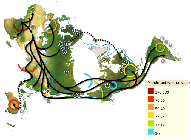
Español: Mapa mundial de migraciones humanas, con el polo norte como centro. Africa es el punto de partida, leyéndose desde la parte superior izquierda hasta América del Sur en el extremo derecho. Los patrones de migración estan basados en estudios del ADN mitocondrial (matrilinear). Los números representan miles de años.
English: World map of human migrations, with the North Pole at center. Africa, harboring the start of the migration, is at the top left and South America at the far right. Migration patterns are based on studies of mitochondrial (matrilinear) DNA. Numbers represent thousand years.
Français : Carte du peuplement de la Planète. Le planisphère présente le Pôle Nord au centre. L'origine du peuplement humain est en Afrique, en haut à gauche et, L'Amérique du Sud tout à fait à droite. La cartographie est réalisée d'après les résultats de recherches scientifiques,publiées, sur la répartition planétaire des mitochondrie, sur un modèle matrilinéaire (DNA). Les chiffres représentent les années en milliers.
Català: Mapa de les migracions humanes, amb el Pol Nord al centre. Àfrica, que és l'origen de la migració, és a la part superior esquerra i Sud-Amèrica a la dreta de tot. Els patrons de migracions es basen en estudis d'ADN mitocondrial (matrilineal). Els nombres representen milers d'anys. |
| Arange | (UTC) |
| Moõgui oguenohẽ | |
| Apohára |
Editado por Sebastiàn Asegurado |
| Otras versiones |
|


| Esta es una imagen retocada, lo que significa que ha sido alterada digitalmente de su versión original. Modificaciones: Bigger image, continents reflect better the north pole point of view.. La original se puede ver aquí: Mapa mundial.png. Las modificaciones las hizo Coffee3k.
|
Este archivo se encuentra bajo la licencia Creative Commons Genérica de Atribución/Compartir-Igual 3.0.
- Nde reime sãsóme:
- de compartir – de copiar, distribuir y transmitir el trabajo
- de remezclar – de adaptar el trabajo
- Bajo las siguientes condiciones:
- atribución – Debes otorgar el crédito correspondiente, proporcionar un enlace a la licencia e indicar si realizaste algún cambio. Puedes hacerlo de cualquier manera razonable pero no de manera que sugiera que el licenciante te respalda a ti o al uso que hagas del trabajo.
- compartir igual – En caso de mezclar, transformar o modificar este trabajo, deberás distribuir el trabajo resultante bajo la misma licencia o una compatible como el original.
Registro original de carga
This image is a derivative work of the following images:
- File:Map-of-human-migrations.jpg licensed with Cc-by-sa-2.5, Cc-by-sa-3.0-migrated, GFDL
- 2005-08-12T19:10:48Z Avsa 889x635 (280299 Bytes)
- 2005-08-05T21:05:11Z Stevertigo (usurped) 536x380 (82391 Bytes) reupload with similar changes, but without compression/artifacts
- 2005-08-05T21:00:38Z Stevertigo (usurped) 536x380 (30898 Bytes) altered brightness contrast - black/brown blending was distracting in last version
- 2005-07-17T20:30:14Z Avsa 536x380 (112431 Bytes)
- 2005-07-16T18:08:36Z Avsa 745x380 (100955 Bytes) Map of human races migration, according to the mithocondrial dna. All data based on mitomap http://www.mitomap.org/WorldMigrations.pdf I ignored all data I could not understand (for example a dotted line, the +/- and the let
- 2005-07-16T18:03:26Z Avsa 745x380 (100955 Bytes) Map of human races migration, according to the mithocondrial dna. All data based on mitomap http://www.mitomap.org/WorldMigrations.pdf I ignored all data I could not understand (for example a dotted line, the +/- and the let
- File:Mapa_mundial.png licensed with Attribution
- 2009-12-31T20:24:24Z Coffee3k 3661x1974 (2880524 Bytes) Versión con fondo blanco sin transparencia.
- 2009-12-31T20:22:04Z Coffee3k 3661x1974 (12951128 Bytes) {{Information |Description={{es|1=Mapa geográfico mundial sin divisiones políticas ni relieves marinos de libre distribución. Versión con transparencia.}} |Source=http://www.gebco.net/data_and_products/gebco_world_map/ |A
Uploaded with derivativeFX
Marandurenda rembiasakue
Ejopy peteĩ ára/aravo rehe rehecha hag̃ua pe marandurenda ojehechaukaháicha upe jave.
| Ára/Aravo | Michĩháicha | Tuichakue | Puruhára | Jehaimombyky | |
|---|---|---|---|---|---|
| ko’ag̃agua | 09:17 29 jasyporundy 2023 | | 1116 × 818 (3,29 MB) | Joutbis | File uploaded using svgtranslate tool (https://svgtranslate.toolforge.org/). Added translation for ca. |
| 01:11 1 jasyteĩ 2010 |  | 1116 × 818 (3,28 MB) | Coffee3k | {{Information |Description={{es|1=Mapa mundial de migraciones humanas, con el polo norte como centro. Africa es el punto de partida, leyéndose desde la parte superior izquierda hasta América del Sur en el extremo derecho. Los patrones de migración esta |
Marandurenda jeporu
La siguiente página usa este archivo:
Marandurenda jepuru opaite tembiapópe
Ko'ã ambue wiki oipuru ko marandurenda:
- Jeporu ast.wikipedia.org rehe
- Jeporu ca.wikipedia.org rehe
- Jeporu eo.wikipedia.org rehe
- Jeporu es.wikipedia.org rehe
- Jeporu fr.wikipedia.org rehe
- Jeporu fr.wikiversity.org rehe
- Jeporu gl.wikipedia.org rehe
- Jeporu oc.wikipedia.org rehe
- Jeporu pap.wikipedia.org rehe