
Ta'ãnga:Northern Ireland counties + districts.png

Tamaño de esta previsualización: 746 × 599 píxeles. Otras resoluciones: 299 × 240 píxeles | 598 × 480 píxeles | 956 × 768 píxeles | 1275 × 1024 píxeles | 1672 × 1343 píxeles.
Marandurenda moambue'ỹre (1672 × 1343 píxeles; tamaño de archivo: 441 kB; tipo MIME: image/png)
Resumen
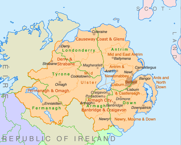
| Mombe'uanga | Counties and disticts of Northern Ireland |
| Arange | |
| Moõgui oguenohẽ | File:Counties of Ireland.svg & File:United Kingdom Northern Ireland adm location map.svg |
| Apohára | Ulamm (ñe’ẽ) |
Licencia
Yo, titular de los derechos de autor de esta obra, la publico en los términos de las siguientes licencias:

|
Se autoriza la copia, distribución y modificación de este documento bajo los términos de la licencia de documentación libre GNU, versión 1.2 o cualquier otra que posteriormente publique la Fundación para el Software Libre; sin secciones invariables, textos de portada, ni textos de contraportada. Se incluye una copia de la dicha licencia en la sección titulada Licencia de Documentación Libre GNU. |
This file is licensed under the Creative Commons Attribution-Share Alike 4.0 International, 3.0 Unported, 2.5 Generic, 2.0 Generic and 1.0 Generic license.
- Nde reime sãsóme:
- de compartir – de copiar, distribuir y transmitir el trabajo
- de remezclar – de adaptar el trabajo
- Bajo las siguientes condiciones:
- atribución – Debes otorgar el crédito correspondiente, proporcionar un enlace a la licencia e indicar si realizaste algún cambio. Puedes hacerlo de cualquier manera razonable pero no de manera que sugiera que el licenciante te respalda a ti o al uso que hagas del trabajo.
- compartir igual – En caso de mezclar, transformar o modificar este trabajo, deberás distribuir el trabajo resultante bajo la misma licencia o una compatible como el original.
Puedes usar la licencia que prefieras.
Marandurenda rembiasakue
Ejopy peteĩ ára/aravo rehe rehecha hag̃ua pe marandurenda ojehechaukaháicha upe jave.
| Ára/Aravo | Michĩháicha | Tuichakue | Puruhára | Jehaimombyky | |
|---|---|---|---|---|---|
| ko’ag̃agua | 22:28 9 jasypokõi 2022 | | 1672 × 1343 (441 kB) | Ulamm | some more names |
| 22:31 8 jasypokõi 2022 |  | 1672 × 1343 (426 kB) | Ulamm | + some places | |
| 12:38 6 jasypokõi 2022 |  | 1672 × 1343 (383 kB) | Ulamm | + Mid Ulster | |
| 12:03 6 jasypokõi 2022 |  | 1672 × 1343 (381 kB) | Ulamm | {{Information |Description=Counties and disticts of Northern Ireland |Source=File:Counties of Ireland.svg & File:United Kingdom Northern Ireland adm location map.svg |Date=2022-07-06 |Author=Ulamm (<span class="signature-talk">{{int:Talkpagelinktext}}</span>) |Permission= |other_versions= }} Category:Maps of Northern Ireland Category:Maps by Ulamm == {{int:license-header}} == {{self|GFDL|cc-by-sa-all|migration=redundant}} |
Marandurenda jeporu
No hay páginas que enlacen a este archivo.
Marandurenda jepuru opaite tembiapópe
Ko'ã ambue wiki oipuru ko marandurenda:
- Jeporu de.wikipedia.org rehe
- Jeporu ie.wikipedia.org rehe
- Jeporu mt.wikipedia.org rehe