
Ta'ãnga:Umbriel (moon).jpg
No disponible a mayor resolución.
Umbriel_(moon).jpg (291 × 302 píxeles; tamaño de archivo: 25 kB; tipo MIME: image/jpeg)
.jpg)
Resumen
| Mombe'uanga |
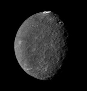
English: Original Caption Released with Image: The southern hemisphere of Umbriel displays heavy cratering in this Voyager 2 image, taken Jan. 24, 1986, from a distance of 557,000 kilometers (346,000 miles). This frame, taken through the clear-filter of Voyager's narrow-angle camera, is the most detailed image of Umbriel, with a resolution of about 10 km (6 mi). Umbriel is the darkest of Uranus' larger moons and the one that appears to have experienced the lowest level of geological activity. It has a diameter of about 1,200 km (750 mi) and reflects only 16 percent of the light striking its surface; in the latter respect, Umbriel is similar to lunar highland areas. Umbriel is heavily cratered but lacks the numerous bright ray craters seen on the other large Uranian satellites; this results in a relatively uniform surface albedo (reflectivity). The prominent crater on the terminator (upper right) is about 110 km (70 mi) across and has a bright central peak. The strangest feature in this image (at top) is a curious bright ring, the most reflective area seen on Umbriel. The ring is about 140 km (90 miles) in diameter and lies near the satellite's equator. The nature of the ring is not known, although it might be a frost deposit, perhaps associated with an impact crater. Spots against the black background are due to 'noise' in the data. The Voyager project is managed for NASA by the Jet Propulsion Laboratory. |
| Arange | |
| Moõgui oguenohẽ | http://photojournal.jpl.nasa.gov/catalog/PIA00040 |
| Apohára | NASA |
| Otras versiones | larger size version |
Licencia
| Este archivo es de dominio público porque fue creado por la NASA. Las políticas sobre copyright de la NASA estipulan que «el material de la NASA no está protegido con copyright a menos que se indique lo contrario». (Políticas sobre copyright de la NASA o Políticas sobre la utilización de imágenes del Jet Propulsion Laboratory). | ||
 |
Advertencias:
|
Marandurenda rembiasakue
Ejopy peteĩ ára/aravo rehe rehecha hag̃ua pe marandurenda ojehechaukaháicha upe jave.
| Ára/Aravo | Michĩháicha | Tuichakue | Puruhára | Jehaimombyky | |
|---|---|---|---|---|---|
| ko’ag̃agua | 23:08 14 jasypoapy 2005 | | 291 × 302 (25 kB) | Vzb83~commonswiki | cropped image |
| 18:44 30 jasyrundy 2005 |  | 400 × 400 (7 kB) | Bricktop | uploaded missing image | |
| 21:18 4 jasyrundy 2005 |  | 252 × 252 (24 kB) | Smartech~commonswiki | '''Original Caption Released with Image''': The southern hemisphere of Umbriel displays heavy cratering in this Voyager 2 image, taken Jan. 24, 1986, from a distance of 557,000 kilometers (346,000 miles). This frame, |
Marandurenda jeporu
La siguiente página usa este archivo:
Marandurenda jepuru opaite tembiapópe
Ko'ã ambue wiki oipuru ko marandurenda:
- Jeporu af.wikipedia.org rehe
- Jeporu als.wikipedia.org rehe
- Jeporu ar.wikipedia.org rehe
- Jeporu ast.wikipedia.org rehe
- Jeporu az.wikipedia.org rehe
- Jeporu be-tarask.wikipedia.org rehe
- Jeporu bg.wikipedia.org rehe
- Jeporu ca.wikipedia.org rehe
- Jeporu ceb.wikipedia.org rehe
- Jeporu ckb.wikipedia.org rehe
- Jeporu cs.wikipedia.org rehe
- Jeporu cy.wikipedia.org rehe
- Jeporu da.wikipedia.org rehe
- Jeporu de.wikipedia.org rehe
- Jeporu de.wikibooks.org rehe
- Jeporu el.wikipedia.org rehe
- Jeporu en.wikipedia.org rehe
- Jeporu eo.wikipedia.org rehe
- Jeporu es.wikipedia.org rehe
- Jeporu et.wikipedia.org rehe
- Jeporu eu.wikipedia.org rehe
- Jeporu fa.wikipedia.org rehe
- Jeporu fi.wikipedia.org rehe
- Jeporu fr.wikipedia.org rehe
Ver más uso global de este archivo.
.jpg)
.jpg)