Ta'ãnga:Geographic distribution of Bengali language.png

Kuatia retepy ndaipóri ambue ñe'ẽme.
Vikipetãmegua

Marandurenda moambue'ỹre(2806 × 2080 píxeles; tamaño de archivo: 1,36 MB; tipo MIME: image/png)

Ko marandurenda haꞌehína Wikimedia Commons guive ha ikatu ojeipuru ambue tembiaporãme. Pe ñemombeꞌupy oĩva marandurenda ñemombeꞌupy kuatia ryepýpe ojehechauka koꞌápe.

Resumen

Mombe'uanga
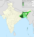
Ελληνικά: Γεωγραφική κατανομή της Βεγγαλικής Γλώσσας ανά επαρχία της Ινδίας και στο Μπανγκλαντές, τα χρώματα στις επαρχίες ποικίλουν ανάλογα με το ποσοστό ομιλητών (δεδομένα απογραφής 2011). Παράγωγο του αρχείου India district map (de-facto).svg.
English: Geographic distribution of Bengali language in India and Bangladesh. The map covers each district of India and the five shades of green show the percentage of Bengali language speakers in each district. Source: Indian census 2011. Feel free to enrich the map with data for more Indian districts, or fix any mistakes. Derivative of the file India district map (de-facto).svg.
Arange
Moõgui oguenohẽ Apohára rembiapo tee
Apohára NikosLikomitros

Licencia

Yo, el titular de los derechos de autor de esta obra, la publico en los términos de la siguiente licencia:
w:es:Creative Commons
atribución compartir igual
Este archivo está disponible bajo la licencia Creative Commons Attribution-Share Alike 4.0 International.
Nde reime sãsóme:
  • de compartir – de copiar, distribuir y transmitir el trabajo
  • de remezclar – de adaptar el trabajo
Bajo las siguientes condiciones:
  • atribución – Debes otorgar el crédito correspondiente, proporcionar un enlace a la licencia e indicar si realizaste algún cambio. Puedes hacerlo de cualquier manera razonable pero no de manera que sugiera que el licenciante te respalda a ti o al uso que hagas del trabajo.
  • compartir igual – En caso de mezclar, transformar o modificar este trabajo, deberás distribuir el trabajo resultante bajo la misma licencia o una compatible como el original.

Leyendas

Añade una explicación corta acerca de lo que representa este archivo
Geographic distribution of Bengali language in India and Bangladesh. The map covers each district of India and the five shades of green show the percentage of Bengali language speakers in each district. Source: Indian census 2011.

Elementos representados en este archivo

representa a español

creador español

Algún valor sin elemento de Wikidata

licencia español

CC BY-SA 4.0 español

26 jasypoteĩ 2022

tipo de archivo español

image/png

Marandurenda rembiasakue

Ejopy peteĩ ára/aravo rehe rehecha hag̃ua pe marandurenda ojehechaukaháicha upe jave.

Ára/AravoMichĩháichaTuichakuePuruháraJehaimombyky
ko’ag̃agua15:05 2 jasypokõi 202215:05 2 jasypokõi 2022 michĩháicha2806 × 2080 (1,36 MB)NikosLikomitrosA few districts of Arunachal Pradesh have a notable Bengali presence above of 1%, probably part of the Indian efforts to increase its presence in the region.
16:55 1 jasypokõi 202216:55 1 jasypokõi 2022 michĩháicha2806 × 2080 (1,36 MB)NikosLikomitrosTwo extra fixes.
16:53 1 jasypokõi 202216:53 1 jasypokõi 2022 michĩháicha2806 × 2080 (1,36 MB)NikosLikomitrosMinor fixes.
16:44 1 jasypokõi 202216:44 1 jasypokõi 2022 michĩháicha2806 × 2080 (1,36 MB)NikosLikomitrosNow, this map covers all districts of India. Includes also extra information and a new colour key. The basemap is from Distribution_of_Jats_in_South_Asia.png.
21:09 26 jasypoteĩ 202221:09 26 jasypoteĩ 2022 michĩháicha1902 × 2048 (1002 kB)NikosLikomitrosUploaded own work with UploadWizard

No hay páginas que enlacen a este archivo.

Marandurenda jepuru opaite tembiapópe

Ko'ã ambue wiki oipuru ko marandurenda:

Apopyme'ẽ