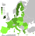
Ta'ãnga:Knowledge of English EU map.svg

Kuatia retepy ndaipóri ambue ñe'ẽme.
Vikipetãmegua

Marandurenda moambue'ỹre(archivo SVG, nominalmente 590 × 603 píxeles, tamaño de archivo: 671 kB)

Ko marandurenda haꞌehína Wikimedia Commons guive ha ikatu ojeipuru ambue tembiaporãme. Pe ñemombeꞌupy oĩva marandurenda ñemombeꞌupy kuatia ryepýpe ojehechauka koꞌápe.

Esta imagen es una infografía creada por un programa informático a partir de conjuntos de datos o fórmulas que no se han proporcionado en su totalidad en esta página. Para permitir que otros editores mejoren o desarrollen dichas imágenes, y para garantizar el cumplimiento de las licencias de contenido libre como la GFDL, se debe proporcionar lo siguiente:
  • Paquete(s) de software utilizado(s);
  • Conjuntos de datos utilizados (si los hay), incluidas las instrucciones de preprocesamiento;
  • Secuencia de comandos utilizados para crear el gráfico;
  • Breve descripción de las etapas de posprocesamiento.
Una vez que todo lo anterior esté incluido en la(s) página(s) de descripción de la imagen, elimine esta plantilla.

Deutsch  English  français  magyar  Nederlands  Plattdüütsch  suomi  македонски  русский  日本語  中文  中文(简体)‎  +/−

Resumen

Mombe'uanga
English: Map, in English of the knowledge of English language in EU.
Deutsch: Karte, die auf Englisch Kenntnisse der englischen Sprache in der EU zeigt.
Français : Carte des connaissances de l'anglais, en anglais, dans l'Union européenne.
Arange (UTC)
Moõgui oguenohẽ
Apohára
Otras versiones


Esta es una imagen retocada, lo que significa que ha sido alterada digitalmente de su versión original. Modificaciones: Hybridised to make vector version of English map. La original se puede ver aquí: Knowledge English EU map.png. Las modificaciones las hizo Alphathon.

w:es:Creative Commons
atribución compartir igual
Este archivo se encuentra bajo la licencia Creative Commons Genérica de Atribución/Compartir-Igual 3.0.
Nde reime sãsóme:
  • de compartir – de copiar, distribuir y transmitir el trabajo
  • de remezclar – de adaptar el trabajo
Bajo las siguientes condiciones:
  • atribución – Debes otorgar el crédito correspondiente, proporcionar un enlace a la licencia e indicar si realizaste algún cambio. Puedes hacerlo de cualquier manera razonable pero no de manera que sugiera que el licenciante te respalda a ti o al uso que hagas del trabajo.
  • compartir igual – En caso de mezclar, transformar o modificar este trabajo, deberás distribuir el trabajo resultante bajo la misma licencia o una compatible como el original.

Registro original de carga

This image is a derivative work of the following images:

  • File:Knowledge_of_German_EU_map.png licensed with PD-self
    • 2009-05-23T22:36:14Z HernauMan 1218x1245 (56214 Bytes) {{Information |Description={{en|1=Knowledge of German language in EU with Croatia, Bosnia and Herzegovina, Switzerland and Turkey. }} |Source=Own work by uploader |Author=[[User:HernauMan|HernauMan]] |Date=2009-05-15 |Permiss
  • File:Knowledge_English_EU_map.png licensed with PD-self
    • 2010-08-13T09:57:14Z RoseAphro 1218x1245 (78412 Bytes) Reverted to version as of 11:13, 2 January 2009 See Discussion
    • 2009-11-10T09:34:49Z Scooter20 1218x1245 (85789 Bytes) Reverted to version as of 10:56, 13 March 2009
    • 2009-07-07T03:55:09Z Kombie2 1218x1245 (61153 Bytes) Corrected wrong text colour in the "NA" in the legend; in an informational map, text colours should be consistent to maximize readability. Also, customarily, a forward slash is entered between the letter 'N' and the letter
    • 2009-03-13T10:56:15Z MacedonianBoy 1218x1245 (85789 Bytes) Since Croatia and Turkey are not part of the EU and they shown, and Macedonia should be since it is candidate
    • 2009-01-02T11:13:54Z The Duke of Waltham 1218x1245 (78412 Bytes) Reverted to version as of 23:47, 15 February 2008 (FYROM is not in the EU)
    • 2008-12-11T12:35:26Z MacedonianBoy 1218x1245 (85789 Bytes)
    • 2008-02-15T23:47:46Z RedCoat 1218x1245 (78412 Bytes) Add Gibraltar.
    • 2006-12-19T09:56:40Z Hoshie 1218x1245 (85776 Bytes) Added Montenegro. Under same license as orginal
    • 2006-11-12T13:50:19Z Aaker 1218x1245 (85716 Bytes) Knowledge of English in the European Union, according to: "Special Eurobarometer 243" of the European Commission with the title "Europeans and their Languages" Made by myself

Uploaded with derivativeFX

Leyendas

Añade una explicación corta acerca de lo que representa este archivo

Elementos representados en este archivo

representa a español

licencia español

CC-BY-SA 3.0 español

27 jasypoapy 2010

tipo de archivo español

image/svg+xml

Marandurenda rembiasakue

Ejopy peteĩ ára/aravo rehe rehecha hag̃ua pe marandurenda ojehechaukaháicha upe jave.

Ára/AravoMichĩháichaTuichakuePuruháraJehaimombyky
ko’ag̃agua10:36 3 jasykõi 202010:36 3 jasykõi 2020 michĩháicha590 × 603 (671 kB)DarrancUpdate since UK left the EU
23:30 15 jasykõi 201523:30 15 jasykõi 2015 michĩháicha590 × 603 (671 kB)LeftcryUpdate layout and information
11:49 17 jasypa 201111:49 17 jasypa 2011 michĩháicha1212 × 1242 (552 kB)Treehilldeletion of Turkey, I let only candidate country with an accession date planned (Croatia and Iceland).
06:34 7 jasyporundy 201106:34 7 jasyporundy 2011 michĩháicha1212 × 1242 (552 kB)Treehill(norway was not deleted before, maybe an error)
20:58 6 jasyporundy 201120:58 6 jasyporundy 2011 michĩháicha1212 × 1242 (552 kB)Treehilldeletion of Norway, as explained previously. Not an EU country (note that the name of the file is "Knowledge_of_English_EU_map.svg").
19:50 6 jasyporundy 201119:50 6 jasyporundy 2011 michĩháicha1212 × 1242 (552 kB)TreehillI deleted Switzerland which is neither in the EU nor a candidate country.
11:12 12 jasypokõi 201111:12 12 jasypokõi 2011 michĩháicha1212 × 1242 (552 kB)J intelaAdded Norway and Switzerland http://en.wikipedia.org/wiki/List_of_countries_by_English-speaking_population
19:08 8 jasyrundy 201119:08 8 jasyrundy 2011 michĩháicha1212 × 1242 (552 kB)AlphathonImproved British Isles
17:42 27 jasypoapy 201017:42 27 jasypoapy 2010 michĩháicha1212 × 1242 (520 kB)Alphathon{{Information |Description={{en|1=Knowledge of English language in EU}} |Source=*File:Knowledge_of_German_EU_map.png *File:Knowledge_English_EU_map.png |Date=2010-08-27 17:41 (UTC) |Author=*File:Knowledge_of_German_EU_map.png: [[User:Her

No hay páginas que enlacen a este archivo.

Marandurenda jepuru opaite tembiapópe

Ko'ã ambue wiki oipuru ko marandurenda:

Ver más uso global de este archivo.

Apopyme'ẽ