
Ta'ãnga:Map of the world with countries and dependencies.svg

Tamaño de esta previsualización PNG del archivo SVG: 512 × 278 píxeles. Otras resoluciones: 320 × 174 píxeles | 640 × 348 píxeles | 1024 × 556 píxeles | 1280 × 695 píxeles | 2560 × 1390 píxeles.
Marandurenda moambue'ỹre (archivo SVG, nominalmente 512 × 278 píxeles, tamaño de archivo: 2,95 MB)
Resumen
| Mombe'uanga |
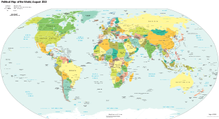
English: This files shows a map of the world politically with islands and countries |
| Moõgui oguenohẽ | https://www.cia.gov/library/publications/the-world-factbook/docs/refmaps.html |
| Apohára | CIA |
| Permiso (Reutilización de este archivo) |
https://www.cia.gov/about-cia/site-policies/#copy |
| Este trabajo ha sido liberado al dominio público por su autor, CIA. Esto aplica para todo el mundo. En algunos países esto puede no ser legalmente factible; si ello ocurriese: CIA otorga a cualquier persona el derecho de usar este trabajo para cualquier propósito, sin ningún tipo de condición, a menos que éstas sean requeridas por la ley.
|
Marandurenda rembiasakue
Ejopy peteĩ ára/aravo rehe rehecha hag̃ua pe marandurenda ojehechaukaháicha upe jave.
| Ára/Aravo | Michĩháicha | Tuichakue | Puruhára | Jehaimombyky | |
|---|---|---|---|---|---|
| ko’ag̃agua | 15:49 25 jasypoteĩ 2019 | | 512 × 278 (2,95 MB) | IceWelder | Compress |
| 17:01 21 jasypo 2019 |  | 512 × 278 (8,85 MB) | Trikkiboy | {{subst:Upload marker added by en.wp UW}} {{Information |Description = {{en|This files shows a map of the world politically with islands and countries}} |Source = https://www.cia.gov/library/publications/the-world-factbook/docs/refmaps.html |Author = CIA |Permission = https://www.cia.gov/about-cia/site-policies/#copy }} {{PD-author|CIA}} |
Marandurenda jeporu
La siguiente página usa este archivo:
Marandurenda jepuru opaite tembiapópe
Ko'ã ambue wiki oipuru ko marandurenda:
- Jeporu ay.wikipedia.org rehe
- Jeporu az.wikipedia.org rehe
- Jeporu en.wikiquote.org rehe
- Jeporu hu.wikipedia.org rehe
- Jeporu it.wikipedia.org rehe
- Jeporu mk.wikipedia.org rehe