Eho kuatia retepýpe

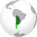
Ta'ãnga:Viceroyalty of the Río de la Plata (orthographic projection).svg

Kuatia retepy ndaipóri ambue ñe'ẽme.
Vikipetãmegua

Marandurenda moambue'ỹre(archivo SVG, nominalmente 550 × 550 píxeles, tamaño de archivo: 609 kB)

Ko marandurenda haꞌehína Wikimedia Commons guive ha ikatu ojeipuru ambue tembiaporãme. Pe ñemombeꞌupy oĩva marandurenda ñemombeꞌupy kuatia ryepýpe ojehechauka koꞌápe.

Resumen

 
Este gráfico vectorial, sin especificar según el W3C, fue creado con Inkscape .
Mombe'uanga
English: Location of the Viceroyalty of the Río de la Plata in orthographic projection, approx. 1796.
 
Sovereign territory.
 
Territories claimed.
Español: Ubicación geográfica del Virreinato del Río de la Plata en proyección ortográfica, aprox. 1796.
 
Territorio soberano.
 
Territorios reclamados.
Arange
Moõgui oguenohẽ

Own work, based on the Image:Brazil (orthographic projection).svg, created by the Wikimedia Commons user Ssolbergj, under a Creative Commons Licence.

Boundaries based in the following sources:

Apohára Keepscases
Permiso
(Reutilización de este archivo)
Yo, el titular de los derechos de autor de esta obra, la publico en los términos de la siguiente licencia:
w:es:Creative Commons
atribución
Este archivo se encuentra bajo la licencia Creative Commons Atribución 3.0 Unported.
Nde reime sãsóme:
  • de compartir – de copiar, distribuir y transmitir el trabajo
  • de remezclar – de adaptar el trabajo
Bajo las siguientes condiciones:
  • atribución – Debes otorgar el crédito correspondiente, proporcionar un enlace a la licencia e indicar si realizaste algún cambio. Puedes hacerlo de cualquier manera razonable pero no de manera que sugiera que el licenciante te respalda a ti o al uso que hagas del trabajo.
Otras versiones
This is a Grey & green orthographic projection map.
العربية: الرجاء، قراءة الميثاق.
বাংলা: দয়া করে, রীতিনীতিটি পড়ুন
Deutsch: Bitte lies die Konventionen.
English: Please, read the conventions.
Español: Por favor, lea las convenciones.
Filipino: Paki-basa ang mga kumbensyon.
Français : S'il vous plaît, lisez les conventions.
हिन्दी: कृपया सभागमों को पढ़ लें.
Bahasa Indonesia: Silakan, baca konvensi.
Italiano: Si prega di leggere le convenzioni.
日本語: 規約をご確認ください。
ქართული: გთხოვთ, გაეცნოთ კონვენციებს.
Português: Por favor, leia as convenções.
Русский: Пожалуйста, прочитайте соглашения.
Українська: Будь ласка, прочитайте конвенції.
Tiếng Việt: Hãy đọc công văn trước khi đăng.
中文(繁體):請檢視常規
中文(简体):请查看常规
World maps

Africa

हिन्दी: अफ्रीका
ქართული: აფრიკა.

Eastern Africa

Southern Africa

Central Africa

Northern Africa

Western Africa

Americas

ქართული: ამერიკა.
हिन्दी: अमेरिका

North America

Central America

Caribbean

South America

Asia

ქართული: აზია.
Português: Ásia.
Українська: Азія.

East

Português: Ásia Oriental.
Українська: Східна Азія.

Central

हिन्दी: मध्य एशिया
Português: Ásia Central.
Українська: Центральна Азія.

Southeast

Bahasa Indonesia: Asia tenggara
Português: Sudeste Asiático.

South

(भारतीय उपमहाद्वीप)
Português: Sul da Ásia.
Українська: Південна Азія.

Western

Português: Sudoeste da Ásia.
Українська: Передня Азія.

Europe

हिन्दी: यूरोप
ქართული: ევროპა.
Português: Europa.
Română: Europa.
Русский: Европа.
Українська: Європа.

Countries

Oceania

हिन्दी: ओशिआनिया
ქართული: ოკეანეთი.
Português: Oceania.
Українська: Океанія.

Intercontinental

Português: Intercontinental.
Українська: Міжконтинентальні.

Historical

English: Unions, Organizations, Kingdoms, Empires
Español: Uniones, Organizaciones, Reinos, Imperios
Filipino: Mga Unyon, Organisasyon, Kaharian, Imperyo
Français : Unions, Organisations, Royaumes, Empires
हिन्दी: संघ, संगठन, राज्य, साम्राज्य व ऐतिहासिक देश
ქართული: გაერთიანებები, ორგანიზაციები, სამეფოები, იმპერიები
Português: Estados extintos.
Tagalog: Mga Unyon, Organisasyon, Kaharian, Imperyo
Українська: Союзи, Організації, Королівства, Імперії
中文(繁體):聯盟、組織、王國和帝國
中文(简体):联盟、组织、王国和帝国

Subnationals

हिन्दी: उपराष्ट्रीय इकाईयाँ

Leyendas

Añade una explicación corta acerca de lo que representa este archivo

Elementos representados en este archivo

representa a español

creador español

Algún valor sin elemento de Wikidata

20 jasypoteĩ 2010

tipo de archivo español

image/svg+xml

Marandurenda rembiasakue

Ejopy peteĩ ára/aravo rehe rehecha hag̃ua pe marandurenda ojehechaukaháicha upe jave.

Ára/AravoMichĩháichaTuichakuePuruháraJehaimombyky
ko’ag̃agua02:56 24 jasypa 202202:56 24 jasypa 2022 michĩháicha550 × 550 (609 kB)JanitoalevicAtacama disputed
08:43 26 jasypo 201208:43 26 jasypo 2012 michĩháicha550 × 550 (609 kB)Franco-eisenhowerDelimitando área indígena inconquistada y verdaderos límites de la Patagonia.
22:52 20 jasypoteĩ 201022:52 20 jasypoteĩ 2010 michĩháicha550 × 550 (138 kB)B1mboCorrected borders and added claims
02:25 21 jasyteĩ 201002:25 21 jasyteĩ 2010 michĩháicha550 × 550 (530 kB)KeepscasesMinor editions
02:50 17 jasyteĩ 201002:50 17 jasyteĩ 2010 michĩháicha550 × 550 (527 kB)KeepscasesGuiana
02:43 17 jasyteĩ 201002:43 17 jasyteĩ 2010 michĩháicha550 × 550 (528 kB)Keepscases{{Information |Description={{en|1=Viceroyalty of the Río de la Plata (orthographic projection)}} |Source={{own}} |Author=Keepscases |Date= |Permission= |other_versions= }} Category:SVG - Orthographic projections

No hay páginas que enlacen a este archivo.

Marandurenda jepuru opaite tembiapópe

Ko'ã ambue wiki oipuru ko marandurenda:

Apopyme'ẽ